Sunday, August 18, 2013

Mt Hood - The Commercial Cascade Peak


Mt. Hood is definitely the commercial part of the Cascade Volcanic Peak circuit.  Don’t get me wrong, the U.S. Park Service pays for its cost in the National Parks by charging nominal fees and selling souvenirs, but for money making, Mt Hood is IT!  Mt Hood is the Ski Resort heaven of northern Oregon.  The south side of the peak is totally commercialized for skiing  they even build a direct four lane road, U.S. 26, directly from Portland to the Mt Hood Ski resorts.  There is still plenty of National Forest land and campgrounds and trails, but none of the Washington State Peaks (maybe some of the nearby peaks on the northern part of Mt. Baker) are commercialized like Mt. Hood.

My plan was to go up on some of the unpaved forest roads to some of the trailheads on the eastern part of the mountain and hike to about the 5500 ft level.  Unfortunately I had a problem with an air leak on the rear left tire and I did not want to risk driving 15 to 20 miles on unpaved roads.  So we took the Tourist option and drove to Timberline Lodge Ski area on the southern part of the mountain.  We did not get to do much hiking due to the lack of time (it takes a couple of hours to drive from the NE side of the mountain to the SW side). 

We stopped to fix the tire just past the Bonneville Dam on the Columbia Gorge – a National Shrine in itself - and stopped to tour the dam.  We drove through the Town of Hood River and up the eastern part of the mountain stopping to check the tire periodically. 

The side trip from our southern trek to California was worth it. 

 Bonneville Dam on the Columbia Gorge


Mt. Hood 11,250 ft. (3,429 m)


At a distance south of Mt Hood is Mt. Jefferson


Mt. St. Helen


In 1980 I was Working at the Pacific Northwest Laboratory (now called Pacific Northwest National Laboratory) About 100 miles east of Mt St Helen.   From our vantage we could see the rolling dark thick clouds of ash rolling toward us.  The scene is like in the movie Triple X when Van Diesel sets off the avalanche to destroy the control center.  The dark clouds coming toward us from Mt St Helen looked like the rolling snow down the mountainside, only they were black and dark grey instead of white.  It was an amazing sight.  We only got about ½ inch of ash in Richland, Washington because the winds were blowing toward the Northeast at that time.  Towns like the city of Yakama were buried in the stuff.  The devastation occurred on the mountain side and on crystal lake.

The whole scene is dramatized in the movie Dante’s Peak with Pierce Brosnan, Linda Hamilton.  The countryside around Mt. St Helen is the same is the movie (although the movie was shot in Idaho) and the movie show lava flows that I don’t think occurred in Mt St Helen, everything else is similar including the  pyroclastic flow, a fast-moving current of hot gas and rock which reaches speeds 450 mph.   The gas can reach temperatures of about 1,830 °F.  Pyroclastic flows normally hug the ground and travel downhill, or spread laterally under gravity. They are a common and devastating result of explosive volcanic eruptions like Mt St Helen or Vesuvius in 79 AD.

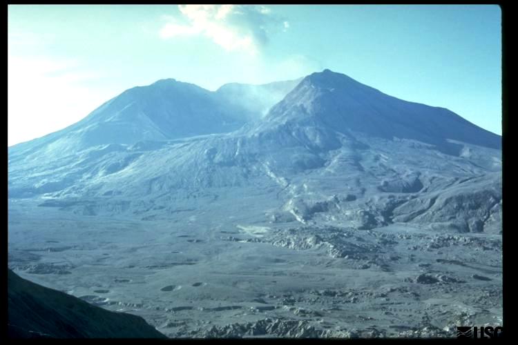
Adrian and I went to Mt St Helen yesterday and hiked up to Windy Point, a small peak in front of the crater that was left after he top 1/3 of the mountain was blown off.  The devastation is still there after 33 years.  The following are pictures of how Mt St Helen looked before, during and after the explosion.  And, How it looks today when we visited the site.

We would have liked to have gotten closer but we did not have time and we did not have special permission (not that they would have given it to us) to hike up to the crater. 

 View in 1980


Views today


 Part of the path to Windy Point

The new dome being build in the middle of the crater
Picture from Windy Point


View of Mt Hood from Windy Point
Our hiking target today!


Saturday, August 17, 2013

The Awesome National Park!


I have never used the adjective “awesome” in any of my communications for a couple of reasons:  President Bush used it so often and that alone made it a useless word.  But the main reason is that it is such a powerful word that almost nothing can measure up to its meaning:  overwhelming, grand, breathtaking, splendid, tremendous, remarkable, amazing, awe-inspiring, astounding, humbling.  That is until my son and I spent 5 days at the Olympic National Park – It was AWESOME!

The Olympic National Park is so large and has so much variety of natural wonders that it would take years to fully explore it.  We only had the opportunity to explore the Sol Duc River Valley; a small portion of the Elwha River Valley;  the Hoh River Valley and the Hoh Rain Forest;  the Kalaloch beaches on the Pacific Coast ; and of course, Hurricane Ridge were we made a 3 and a half mile hike up to Hurricane peak (hill) at 5757 feet.  We also made side trips to the Makah, Ozette, and Quileute Indian Reservations on the Pacific coast.  While at the Makah Reservation, we made a short one mile hike through the dense forest to Cape Flattery, the northwest most point in the U.S.  Of course we could not leave without having the famous Quileute smoked salmon.

Here are some pictures of the park:

The Pacific Coast Part of the Park


 Sea Life at Low Tide


 Our Campsite at the Beach

 Adrian with a friend catching a Berry Jelly Fish

  At the Hoh Rain Forest
 At the Hoh Rain Forest

  At the Hoh Rain Forest


The Mountain Side of the Park 


A view of part of the 3 mile hiking path


Mt Olympus


On Hurricane peak with Mt Olympus in background


The deer were very tame


The Sol Duc River Valley 


Crescent Lake near entrance to Sol Duc River Valley

Sol Duc Campground


 Adrian walking across fallen tree


Cape Flattery Most Northwester Point in U.S.


If you look close you can see the Chinese Coast about 5000 miles away behind Adrian